Paul Brown

Fera Science

How to Use Drones to Enhance Your Crop Yields

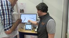
3D field surveying can be used to model landscapes and ecological compositions, providing important information which can then be used by farmers to optimize field plantation and pest prevention. In this video, Paul Brown describes techniques to use a UAV (unmanned aerial vehicle, or more commonly, drone) field survey system at Cereal 2015.


LIKE 0


Paul Brown
Environmental Science

Paul Brown

Biography

Paul is a GI remote sensing scientist with an extensive range of experience in remote sensing, image processing and GIS analysis. More
Follow Paul

Paul Brown

Fera Science

Paul is a GI remote sensing scientist with an extensive range of experience in remote sensing, image processing and GIS analysis. Additionally, Paul is a qualified UAV (unmanned aerial vehicle or drone) pilot, highly experienced piloting both fixed-wing and rotary UAVs. He has extensive knowledge of a wide variety of software packages required for image processing and analysis including Pix4D, ERDAS IMAGINE, ER Mapper, eCognition, ArcGIS, PCI Geomatica, Global Mapper, QGIS and GRASS amongst others.